Weather Outlook: La Niña Year Three
The overarching story for the winter of 2022/23 will likely be the long-running La Niña conditions in the equatorial Pacific. This will be the third winter in a row featuring below-normal sea surface temperatures in this area. The “triple dip” La Niña is a relatively rare phenomenon as it has occurred only two other times since 1950, with the most recent being during the mid-1970s. La Niña may moderate to more neutral or normal conditions by mid-winter. The exact timing of this transition may have implications for the temperature and precipitation patterns across the United States, as the stronger and earlier it occurs, the more impactful it will be in shifting toward a more El Niño-influenced pattern.
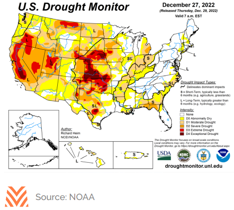
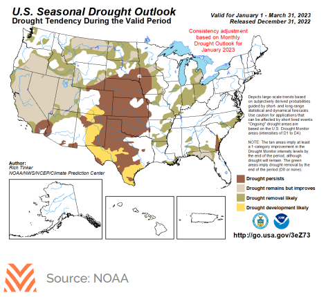
Across the northern tier of states from the Pacific Northwest to the upper Midwest, the general influence of the La Niña pattern will be for an active storm track, bringing colder-than-normal temperatures and above-average amounts of precipitation. This should generally be helpful in reducing some drought conditions that have persisted throughout the summer and fall of 2022. Unfortunately, the active storm track across the northern tier does not portend favorably for the rainy season in California and other areas of the West south of the Pacific Northwest and northern Rockies. This trend will likely be more significant closer to the Mexican border. Far northern California may see some impact from the northern storm track, which would be beneficial to the reservoir system there; however, overall, it seems that the water year could be challenging. As mentioned above, one wild card for the weather outlook is the speed of transition away from La Niña. If that were to occur earlier in the winter, it would bring enhanced chances for precipitation to California.
The central Plains through the Ohio Valley and interior Northeast are likely to experience temperature volatility as mild air rushes in from the south ahead of the northern storm track, followed by onrushing cold air in the wake of the storms. These clashes in temperature would energize storms and result in a mixture of precipitation. However, snowfall is likely to be above average in this region. The southern tier from Texas through the Southeast will likely remain drier and warmer than usual, which would exacerbate drought conditions in this area.