La Niña to Drive Weather for Early 2022 Growing Season
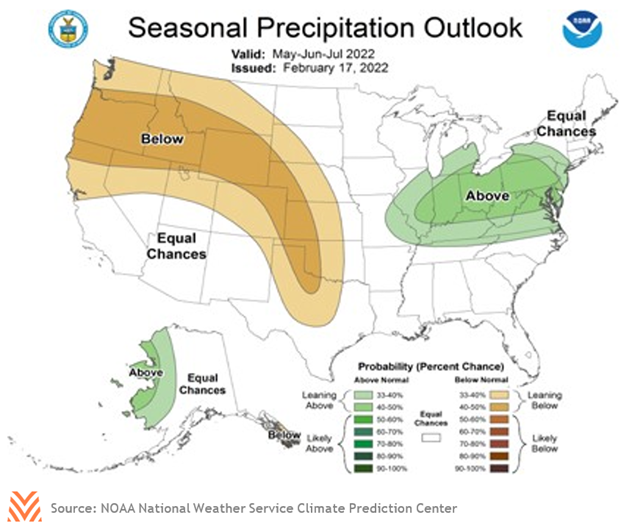
La Niña conditions continue to dominate near-term weather outlooks, with the National Weather Service Climate Prediction Center estimating that it will persist through May before transitioning to a neutral weather pattern. Current estimates suggest that the pattern will retain its current strength through May, rather than subsiding gradually. Near-term outlooks continue to reflect this pattern; wetter than normal conditions in the Pacific Northwest and around the Great Lakes, colder than normal temperatures in the northern Plains states, and drier conditions across the Southwest.
However, the longer-term outlook paints a picture that could compound drought issues in parts of the Pacific Northwest and Plains regions. While the La Niña pattern has led to minor improvements in soil moisture and pasture conditions in the Pacific Northwest, many of these states still face considerable drought. Winter snow is a critical source of water in California, and December featured record-breaking snows; however, January and February were among the least snowy months in California’s history. As a result, a promising start to the water year will likely finish with below-normal moisture, which will exacerbate the longer-term drought conditions during the summer. The NASS February report for Montana indicated that 75% of farmland was short or very short. Further east, in states like South Dakota, drought conditions are leading to 15% or greater declines in forage production. States in the southern Plains are observing abnormally dry conditions, even if topsoil conditions suggest adequate water. Current projections for the growing season indicate that these states could see below-average precipitation through the summer, compounding the challenges they already face.
The flip side of this issue is being faced by some states in the eastern Corn Belt and South. At the end of February, more than half of farmland topsoil in Ohio and Indiana had a water surplus. The La Niña pattern has led to a mild winter in parts of the south that has helped jump-start growing conditions. But the pattern is also likely to continue to lead to wetter conditions throughout the region, which may have implications for springtime fieldwork. Hazard predictions suggest heavy precipitation is possible throughout the South and Appalachian regions, with flooding possible along the Wabash river watershed and portions of the Mississippi River bordering Missouri and Arkansas.
Temperature predictions for the 2022 early growing season show less regional variation. Following the breakup of the La Niña pattern, temperatures are likely to be above normal across most growing regions. Temperature anomalies are likeliest in the Southwest, where hot weather may exacerbate drought conditions, while the Pacific Northwest may see fewer anomalies. Recent forecasts have raised the likelihood of higher temperatures across the Rio Grande Valley and northern Plains states.
In general, producers can expect weather to be slightly atypical to start the growing season, almost regardless of region. The likelihood of severe weather events across the Pacific Northwest and Corn Belt may be elevated in the near term. Flooding maybe more likely in some northern regions, while drought conditions may be exacerbated across the South. Current projections suggest drought impacts will be centered on cattle and winter wheat regions, suggesting additional weather-related strain for those commodities.