La Nada, No Problem: Weather Outlook for 2025 Harvest and Beyond
Watching the Skies: Late Summer and Fall Weather Outlook
As late summer settles in, farmers, ranchers, and power providers are keeping a close eye on the weather to guide harvest planning and operational decisions. This year, the climate is in a neutral phase—neither El Niño nor La Niña—commonly referred to as “La Nada.” This neutral pattern is expected to persist through the fall, with a slight shift toward La Niña as winter approaches. Historically, La Niña tends to influence winter conditions more than fall weather.
Warm Nights and Shifting Patterns
Recent months have brought unusually warm nighttime temperatures across much of the Midwest, Ohio Valley, and Northeast, driven by persistent humidity and moisture. While daytime highs have not been extreme, the elevated nighttime lows have set records in several regions.
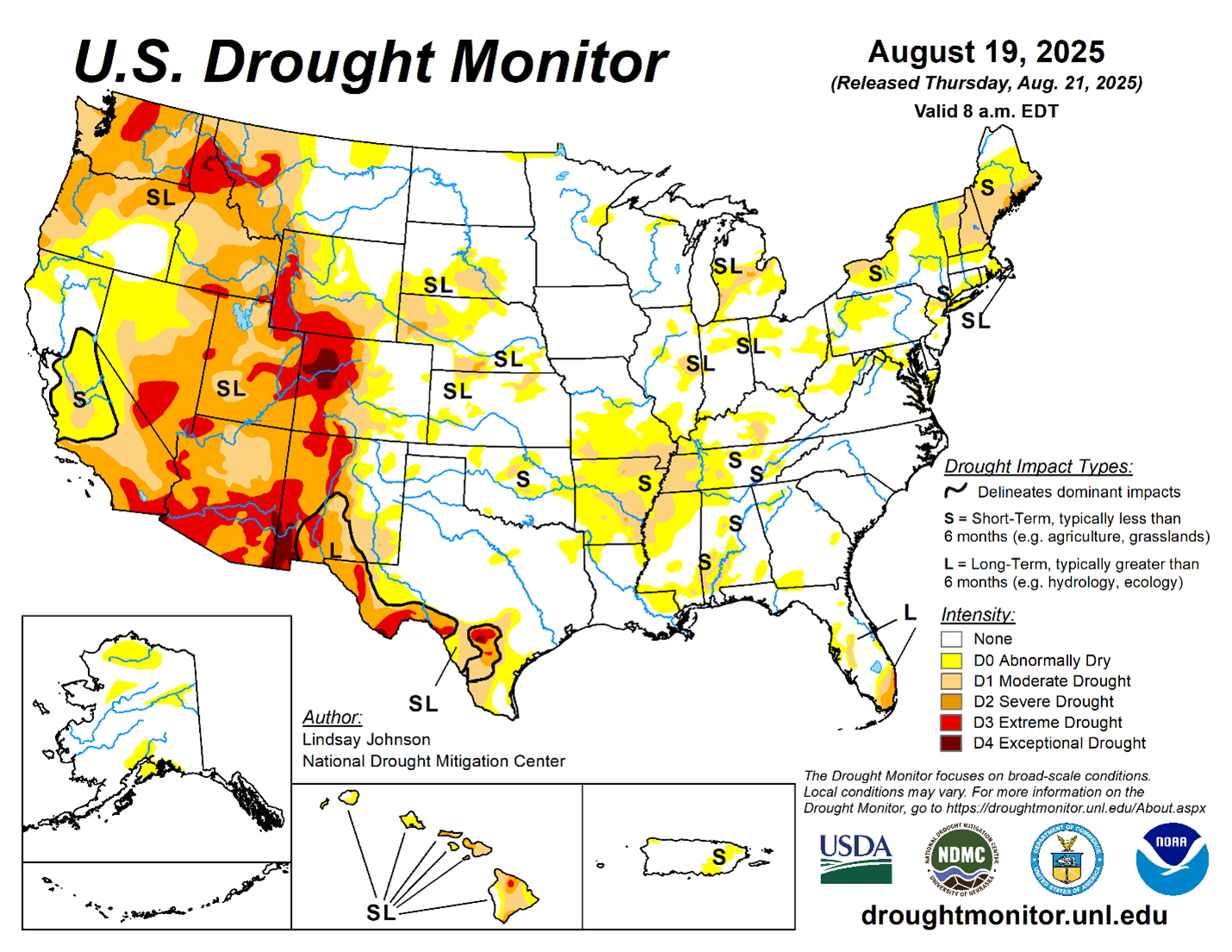
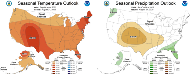
Looking ahead, weather models indicate that the upper-level ridge responsible for the humidity will shift westward and modify, bringing drier and warmer conditions to the upper Midwest and Plains. Parts of these areas could see temperatures as much as seven degrees above normal, with a corresponding decrease in rainfall. This pattern is expected to continue into September, with the core of the heat moving further west.
Harvest-Friendly Conditions Ahead
By October and November, cooler air is projected to move into the northern Plains and Northwest, while the Midwest remains generally mild and dry. These conditions are favorable for harvest, as dry weather helps crops mature, reduces the risk of mold or mildew, and improves field accessibility for machinery.
Precipitation is expected to be below normal in the Midwest during the harvest period, with any significant rainfall more likely to occur in the Mississippi Valley and Southeast. The overall outlook points to a mild, dry fall for most of the core grain-producing regions, with cooler weather arriving closer to winter.
Atlantic Hurricane Season: Quiet So Far
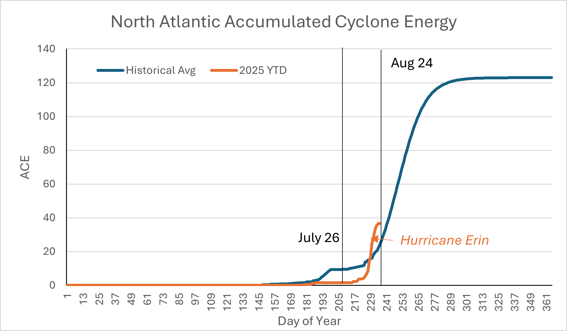
Hurricane activity in the Atlantic has been well below normal to date, but a seasonal uptick is possible in September. Accumulated cyclone energy (ACE) is one measure meteorologists use to indicate tropical storm activity across years. As the graph below highlights, through July 2025, this year’s ACE was far behind recent years’ levels as well as the historical average. Even with the pickup in cyclone activity in the Atlantic with storms Erin and Fernand, the total number of storms is likely to finish below average. While the Southeast may see some increased rainfall from late-developing storms, current models suggest a declining probability of an above-average hurricane season.
Weather Around the Horn
In California, the upcoming water year is expected to bring below-normal precipitation. While not likely to reach drought levels, the forecast does not support an above-average snowpack or reservoir refill. Fortunately, California reservoirs entered this water year at above-average levels, reducing the necessity of a large snowpack over the coming year.
For Brazil, weather models project adequate rainfall for the spring planting season, supporting a strong start for soybeans and other crops. This, combined with favorable U.S. conditions, could lead to abundant global grain supplies and continued pressure on commodity prices.
Bottom Line
Overall, the late summer and fall weather outlook suggests favorable conditions for harvest in the Midwest, manageable risks for the Southeast, and a watchful eye on water supplies in California and crop progress in Brazil.
